

A brief guide to Scilly's 290 million year history
Geology tour
Map and guide to some interesting geological features -what to look for and where to find them.

The granite outcrops and pebbles you see on the shorelines of Scilly are about 290 million years old. They were formed from a large body of molten rock, or magma, known as a pluton, reaching 10 km down into the ground and under the sea all around Scilly.
The Scilly pluton is one of
a group, joined deep underground in a
single mass extending through Cornwall and Devon as far as
Dartmoor.
Cornubian batholith Read more >>

Over three hundred million years
ago, the molten granite lay under sandstone and mudstone sediments
at the bottom of an ancient sea located along the southern margin
of Britain.
Collision of ancient continents in the region of southern England and northern France formed a mountain belt, much like the Himalayas today, but extending from the southeastern USA through France and Spain to eastern Europe.
Variscan orogeny Read more >>

The buoyant
molten granite rose up under these mountains, cooled and
crystallised, binding the deep roots of the old mountain
belt.
As a
result, the British Isles are held in the quiet interior
region of a continental plate, away from the geologically active
edges.
Tectonic plates Read more >>

The Scilly granite pluton was
thus one of the last drops of geological glue that helped assemble
the rock foundations of Britain into their current
state.
The Scillonian granite you see now was a few kilometres underground when it solidified, a process which took millions of years. The chemical composition of the granite shows that it was formed from rocks that melted deep in the Earth’s crust.
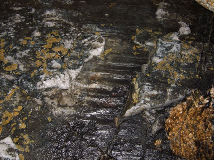
Whilst still molten, the cooling granite was stressed by Earth movements, leading to flow and alignment of crystals that formed early in the granite. Similar movements after it had solidified made cracks and joints. In some places, minerals crystallised out from fluids injected into the cracks.
Over much of Cornwall these fluids contained commercially valuable metals, such as tin and copper. The Scilly pluton is unusual as it seems to lack these metal ores, but it does have veins of white quartz and black fibrous tourmaline.
The hot granite pluton heated and altered the older sandstone and mudstone “country rocks” as it rose up into them. Later, uplift and erosion of southwest England exposed the altered rock and the deep roots of the old mountain belt, including the Scilly pluton. These exposed rocks were also subject to erosion.
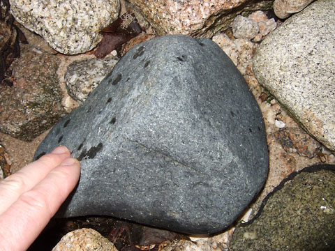
Because of the millions of years of erosion, you would have to dive down to the seabed offshore to see the country rock in place, but you can find pieces of the red sandstone and grey mudstone rock as pebbles on some beaches in Scilly.
As they eroded away, fragments of the country rocks that once overlay the granite pluton were transported as far as Devon, Dorset and Hampshire, where they formed new sedimentary layers of rock, embedding dinosaur skeletons.
The erosive powers of the wind and sea also sculpted dramatic granite rock formations in Scilly, and provided the white quartz and milky feldspar grains in the sandy beaches.

During the last Ice Age, 21,000 years ago, a large glacier flowed southwards down the Irish Sea Basin reaching as far as the northern extremities of Bryher, Tresco and St Martin’s.
The northern glacial deposits contain flint eroded from the floor of the Irish sea; this resource was used locally in Stone Age times to make tools. Some of these tools are on display in the museum, on St Mary’s. It is likely that earlier glacial events affected Scilly, but any evidence for these has been eroded by the events of the last Ice Age.
The moraines at the north end of St Martins (Pernagie bar and White Island bar) provide visible evidence of the southern tip of this glacier. South of this ice limit, cold tundra conditions resulted in the accumulation of orange-brown deposits known locally as “ram”.

This ram is still visible in the cliffs around the islands. In places, the ram contains organic deposits including pollen of tundra plants, radiocarbon dated to the interval between 21,000 and 30,000 years ago.

As the climate warmed and the ice melted, it would initially have been possible to walk from Scilly to Cornwall, South Wales, Brittany, and Ireland, but eventually sea levels rose, forming a large single island, and ultimately the archipelago we see today.
For a Geological Tour of the islands describing features which are evidence of these geological processes Click here >>
Explore martian meteorites, UK rocks, geological curiosities and lots more at the Virtual Microscope >>
Visit the Geological Society online for:
Find out more about minerals in the Minerals Education Coalition web pages
Learn about geological processes with the British Geological Survey exploring geological time, hazards,
maps and climate change and join their citizen science projects.
Copyright © 2016 Creative Commons